Antelope Mountain
ANTELOPE
MOUNTAIN
 |
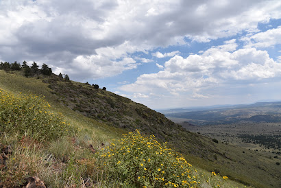
| View from the saddle of Antelope Mountain near Greer |
A drive
along State Route 260 in the White Mountains between Pinetop-Lakeside and
Springerville is a tour of extremes.
 |
| Fish Creek Corral frames a view of Antelope Mountain |
The scenic
byway begins in dense woodlands replete with lakeside retreats that comes to an
abrupt end near the turn off for the town of Greer where the landscape jumps
from piney to pastoral.
 |
| Ellis Wiltbank Reservoir sits at the base of Antelope Mtn. |
Like a splash of
cold water, the terrain suddenly changes into sprawling grasslands and isolated
pine-covered knolls. Figuring prominently in the landscape are hundreds of
lumps, bumps, slumps and conical hills--welcome to the complex geology of the
Springerville Volcanic Field. This swath
of cinder cones and lava flows sits at the southern edge of the Colorado
Plateau, a roughly 130,000 square mile collection of some of the country’s most
remarkable landforms (think: Zion, Capitol Reef and the Grand Canyon) that
covers the four corners region of Utah, Colorado, New Mexico and Arizona.
 |
| A monsoon storm builds over Antelope Mountain |
 |
| Springerville Volcanic Field seen from Antelope Mtn. |
Sparsely
vegetated, the sunny plains sit just north of the course of the Little Colorado
River and its tributaries that drain into the Mount Baldy Wilderness area where
a mass of lakes, marshes and moist riparian zones stand in stark contrast to
the shrubby, windswept volcanic highlands.
 |
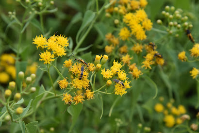
| Insects feed on a Mountain tail-leaf bush on Antelope Mtn. |
Hiking in
this bizarre area is both challenging and rewarding.
 |
| A textbook-perfect cinder cone seen from Antelope Mtn. |
While
10,134-foot Greens Peak, the highest point in the field, is easily accessible
on national forest land, many of the other notable volcanic features in the
area are located along rough back roads that pass through a patchwork of
national forest, state trust, tribal, municipal and private lands, so it’s
important that you trek in sync with the laws.
 |
| Pollinators alight on New Mexican vervain blooms |
Once such
place to explore is Antelope Mountain, a fascinating cinder cone which is on
State Trust Land. A permit is required
to hike the rough dirt road to its 9,003-foot summit. State Trust Land
Recreational permits are inexpensive, easy to obtain online and most, including
the one for individual hiking access, are good for a full year. In some cases, such as where Passage 30:
Coconino Rim of the Arizona Trail crosses State Trust land north of Flagstaff, a
permit is not required as long as you stay within the 15-foot corridor of the
trail. That is an exception, though. If you’re recreating on State Trust land,
you’ll need a permit.
 |
| Antelope Mountain is a cinder cone volcano |
 |
| Steep approach to the saddle of Antelope Mountain |
The deceptively
easy-looking road that climbs Antelope Mountain begins at a nondescript turnout
off State Route 260 six miles north of the town of Greer. The first mile is a simple traipse among
spotty trees and the wire-and-wood complex of the Fish Creek corrals where the
first of two road gates marks the warm up section to the steep climbing ahead. From
this segment, the road cut that snakes up the nearly treeless mountain is
clearly visible. While it may not look that imposing from a distance, it makes
a steady, 30-degree ascent with no breaks. It’s all up, all the way.
 |
| A hazy view of Escudilla Mtn on the far right horizon |
 |
| Road cut visible on the barren south slopes of Antelope Mtn. |
Soon,
glimpses of Ellis Wiltbank Reservoir, which is on private property, appear in a shallow basin to the left of
the road. Look carefully and you might spot domestic cattle, elk and big horn
sheep roaming around its mucky perimeter.
At near the 1.5-mile point, pass a second gate that marks the State Trust
Land boundary (per state land regulations, leave the gate as you found it, either
open or closed) and get ready for the uphill grind. One hairpin switchback at the 8,500-foot
point is all you get in terms of climb-mitigating road engineering. The rest of the hike makes a straight shot up
the mountain’s south flank to the top with the final quarter-mile to the saddle
below the summit ridge being the steepest. But great vistas of Escudilla
Mountain on the New Mexico border, Mount Baldy, Pole Knoll and White Mountains grasslands
take the sting out of the effort.
 |
| Late summer is the best time to see sunflowers in the White Mtns. |
 |
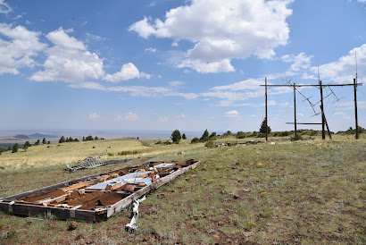
| Defunct communication equipment on Antelope Mtn. |
 |
| Looking west from the lone switchback on Antelope Mtn. |
On the
saddle, the road splits. The left fork goes to the summit proper while the
right one leads to scenic overlooks and a heap of defunct equipment, including
what appears to be old analogue TV antennas.
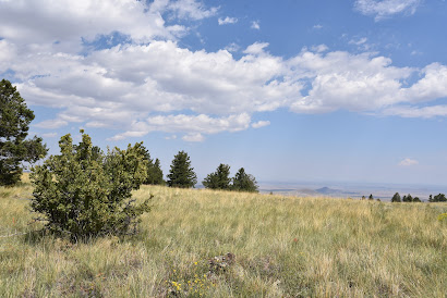
A smattering of wind-tortured fir trees standing among outcroppings of
basalt boulders and scree line the summit spur. Visible between the trees, a textbook-perfect
cinder cone with a symmetrical crater sits 500 feet below the mountain’s north
face while dozens of other more lopsided and eroded specimens are scattered on
the prairies below.
 |
| Forest Road 558 leads to the top of Antelope Mountain |
 |
| Looking east from the summit of Antelope Mountain |
 |
| A wild geranium blooms among buckwheat flowers |
The road
tops out on a bald knob where a huge cairn made of cinders denotes the
mountain’s highpoint. On the top, the
tower-clutter summit of Greens Peak can be seen to the west while the diverse
mix of forests and open plains of east-central Arizona roll out all around
making the quad burning hike well worth the effort.
 |
| View from the saddle of Antelope Mountain |
 |
| Greens Peak (far R horizon) seen from Antelope Mtn |
 |
| A permit is required to hike on Arizona State Trust Land |
LENGTH: 6 miles round trip
RATING:
moderate
ELEVATION: 8,149 – 9,003 feet
GETTING
THERE:
From Show
Low go 45 miles east on State Route 260 (White Mountain Blvd.) to Forest Road
558 on the left. This easy-to-miss road
is located 0.7-mile past the State Route 373 turn off for the town of Greer, just
past a big Leaving Apache National Forest sign. There’s a parking turnout a few
yard in and additional parking farther up the road near a corral. Hike the road to the summit.
AN ARIZONA
STATE LAND TRUST RECREATIONAL PERMIT IS REQUIRED FOR THIS HIKE. GET ONE HERE:
https://land.az.gov/applications-permits/recreation
INFO on
the Springerville Volcanic Field
http://azgs.arizona.edu/azgs-photo-tags/springerville-volcanic-field
Kommentare
Kommentar veröffentlichen